Tuesday, June 4, 2013
Sunday, May 19, 2013
The Massive Movement Project
The Massive Movement Project
Ptolemy thought the earth is in the center of the universe, which is Geocentric model. But after many years, a scientist who learned astronomy named Copernicus, he thought the sun is in the center of the universe, which is Heliocentric model. Two evidences can support Heliocentric model are the seasons and the movement of the starts.
Rotation is the motion of the Earth, it get support from the axis. Rotation length is 24hours/day. The axis is a imaginary line in the central of the Earth. The tilt of the Earth's axis is 23.45 degrees. Equator is the imaginary that around the Earth, it is 0 degree. Equator divided earth into two hemispheres, there are northern hemisphere and southern hemisphere. polaris is important because the axis always point it, and Polaris always in the north. Two evidences can support rotation are pendulum (swing) and Coriolis effect.
Revolution is the earth move around the sun. Revolution length is 365 days or a year. The orbit is earth revolution process the curbed path. The shape of earth's orbit is ellipse. Aphelion is far to the sun, but perihelion is near to the sun. Constellation is the shape in the sky that made many stars connect. Two evidence can support revolution are soilors notices changes in how the night sky looked and stars.
There are 24 time zones in the world, time zones dividend by longitude. The International Date Line ( IDL) is the line changing the calender days. The Greenwich Mean Time (GMT) is the town where time begin.
There are four season: Spring, Summer, Fall, and Winter. But there is not season at the equator because it always hot. Direct is more sunlight, but indirect is less sunlight. Two main causes of the Earth's seasons are: the earth moves around on it's orbit, and different places get different sunlight.
The winter solstice is the earth is far from the sun, the date of the winter solstice is Dec. 21 or 22. The summer solsticce is the earth is near to the sun, the date of the summer solstice is June 21 or 22.
Equinox is when earth receive the same amount of the sunlight. The date of the Vernal (Spring) Equinox is March 21 or 22. The date of the Autumnal (Fall) Equinox is September 22 or 23.
The phases of the Moon is different forms that the moon takes from the Earth. Moon get its light from the sun. There are five different moons: New moon (no moon, cannot see the moon); Crescent moon (less than half); Quarter moon (half); Gibbous moon (more than half); Full moon (circle, all). Waxing means getting bigger, but waning means getting less.
Lunar Eclipse is when moon goes above or below the earth's umbra. Total lunar eclipse is full, partialeclips lunar eclipse is half. Solar Eclipse is the moon is between sun and earth. The new moon is a solar eclipse. The total solar eclipses is when moon fully blocked the sunlight. But the partial solar eclipses is only part of sunlight is blocked.
Tide is the ocean moving high and low, moon is the main cause of the earth's tides. Spring Tide is the tide is higher or lower than a normal tides. Full Moon and New Moon are Spring Tides. When moon, earth, and sun are at 90 degrees angle that is called Neap Tide. 3rd quater and 1st quater of the moon are Neap Tides.
Friday, March 15, 2013
Earth's Face
Earth's Face
Plate tectonics is the big plate was from the 2 or 3 hundred million ago, it is called the Pangaea, but after 220 million, the continental drift was happened. Continental drift is the process that making the plats moving, continents shift along with them. I agree with the theory of plate tectonics, because from my research, many activities in the Earth can slowly change the face of the Earth, and many things can support this theory, such as the mountain, fossil, desert, and etc.
Evidence 1-- Plate boundary ( Make the plates moving, change the face of Earth)
Convergent boundary
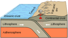 When two plates are coming together, it can creates the mountain on
the crust.
When two plates are coming together, it can creates the mountain on
the crust. Divergent boundary

Transform boundary
Evidence 2 --Puzzle

 The Pangaea was a big piece plate that are from the 200 or 300 million ago. If we cut out the map, and put all continent together, it can support the all plates are come from one big plate.
Evidence 3-- Fossil
 When plates were separate, the scientist found the same fossil in the two different plates. It can support these plates were together, but after they are separate.
Through these evidences, they can support the continental drift makes the plates are separate. In my opinion, I think when the plate boundaries are moving, the surface is slowing change, because when two plates together, there is a new mountain born, when two plates are moving apart, it is a new rift valley, or volcanoes, when two plates are past each other, the earthquake( Land move) was happened. Therefore, the pangaea separated because these activities on the crust.
Reflection
What did you enjoy most about this project and why?
In this project, I think to research the something I don't understand is the part I most enjoy, because I can know more knowledge from my research.
What most challenging for you during this project and why?
I think the most challenging part in this project is to learn something independent, because I need to find the information by myself. Such as, the watch the brainpop about the new topics, do the labs, presentation, or etc. ( But it is fun)
What new skills did you learn from doing this project?
From doing this project, I learn how do use the Prezi, it was my first time to used to Prezi to shows my evidences. I think it is a skill that I learned.
Is there anything that you could have done to improve any of your work? Explain.
I think I can improve my photograph evidences, because I think it is not very good, because I was not showing everything on the prezi.
What would you change about this project?
I think if I do this project again, I will to change the photograph evidence to essay, because I think the photograph evidence can not shows everything that I learned. Wednesday, February 27, 2013
Thursday, January 17, 2013
Natural Disaster-Evidence

Evidence 1
It shows Japan is locate on the 4 plate boundaries: Eurasian Plate, North American Plate, Philippine Plate, and Pacific Plate. When two plates are moving, it would happen earthquake and tsunami in Japan. Therefore, Japan is happen the tsunami most in the world.


Evidence 2
This picture is
showing the amount of the Tsunami happen in the Japan. The point is shows the
most Tsunami happen is in the North East of the Japan.

This map is showing the countries that on the Pacific Ocean or close to the Pacific Ocean, there tsunami are more than the country that not close to the ocean

This graph shows the tsunami in Japan is more than the tsunami in other country.
Monday, January 14, 2013
Conclusion
Tsunami
is a giant wave that cause by the earthquake under the ocean that makes the
giant wave. This natural disaster can have many negative effect for our life.
For example, submerge everything by giant wave; flooding;
homeless; and etc. In my research I find the historical tsunami happened in the
world. My first evidence that shows the Japan’s location can cause it has most
tsunami in the world.
My
second evidence that shows the which city in Japan has most tsunami. If the
tsunami continues for the next 100 years, that can make many countries or
cities under the water.
Subscribe to:
Comments (Atom)